Voting Map
The USA Today map of the county-by-county results is below:

So Kerry won: (1) Big cities; (2) Parts of the far northeast; (3) The Mississippi Delta region; (4) Other regions of Southern states that have high black populations; (5) The area in Texas that has the most Mexican immigrants; (6) Parts of Appalachia; (7) In the Western states, areas that have Indian reservations (a map of reservations is here, and it very closely matches Kerry's county wins in Montana, New Mexico, Arizona, and South Dakota, for example). All of that seems intuitively obvious, but the one region I can't figure out is the big pocket of blue in Iowa and southern Wisconsin. Something to do with farming policies, perhaps?
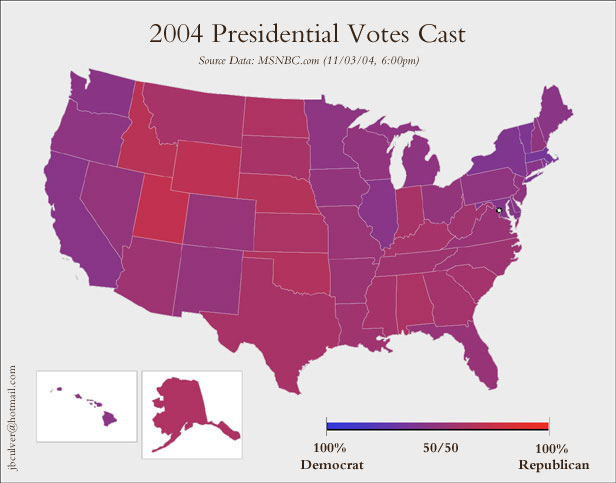
The following image, from Boing Boing, is more sophisticated, as it scores all of the states based on the proportions that voted Republican or Democratic. Instead of vast seas of red punctuated by little pockets of blue, you see vast seas of . . . purple. Which makes sense, because it's not as if Democratic voters were completely absent in all the states that Bush won, or vice versa.


1 Comments:
That blue splotch along the Upper Mississippi tracks pretty well with old industrial river towns starting at Minneapolis/St Paul, MN and extending south to the Quad Cities (Davenport and Bettendorf, IA, Rock Island and Moline, IL). This area is a mini-Rust Belt and a strong union area, like that blue splotch around Pittsburg, PA and in northeast Ohio.
The eastern part of Iowa is relatively more urban than the rural western half. The blue counties track pretty well with the locations of Waterloo-Cedar Falls and Cedar Rapids-Iowa City, IA. Both of these areas have a university combined with an old industrial union base that historically leans democrat. The Iowa capital, Des Moines, and its suburbs anchor the western most edge of this area, and tend to be pro-government and democrat leaning.
The rest of the blue counties in southwest WI, north IA, and southern MN are probably more residual democrat support from the New Deal/New Frontier than a reflection of recent farm policies. There is a pretty strong isolationist streak out here, even among republicans. I don't know if that would have swung any traditional republicans to vote for Kerry but the Iraq war might have depressed turnout among voters who would have favored Bush otherwise.
Chris B
Cedar Rapids, IA
sojyrner@hotmail.com
Post a Comment
Subscribe to Post Comments [Atom]
<< Home